Map Notes :[]
To allow for square maps to make up a spherical world - there are variable amounts of distance between the square maps. Usually this space between maps is narrow, and typically narrower at one end than the other - in general these locations are not mapped but in _some_ instances we do utilize this marginal space when needs dictate. Each Area is 16x16 TILES or 160 meters on a side (the small squares in the maps below are Areas). Each group of these Areas (7x7 = 49) are 1120 meters on a side. These groups ... nearly 50 Areas ... what is shown below is roughly 75% of the c. 400 contiguous surface Areas in the current module (available to PLAYER use) ... though the module also has many far flung regions represented within it, this is the largest contiguous piece of surface terrain in the current module. We have just made available two more provinces... nearly 100 more contiguous Areas, west of the city and Tivook. As of this writing, there are a total of 392 contiguous surface Areas around the city of Dohral for your exploring enjoyment.
Quick Distance details:
Each Area= (160*160 meters) 25600 meters squared / (0.10* 0.10) 0.01 miles squared surface area.
Each Region= (1120*1120 meters) 1.25 kilometers squared / (0.7*0.7) 0.5 square miles surface area.
Total Available Surface Areas= ((1120*4)*(1120*2))10.04 kilometers squared/ 3.9 square miles.
These are rough estimates on the distance between settlements:
- 800 meters/0.5 miles to get from the gates of North Chonda In Dohral (NCD) to Tivook Crossing (The North Road).
- 2.75 kilometers or 1.7 miles to get from the gates of NCD to the Eastern Citadel, 1950 meters/ 1.2 miles from Tivook Crossing to the Eastern Citadel (The East Road).
- 2.45 kilometers or 1.5 miles from NCD to Hillsbottom (Humfoo Crossing) and a further 650 meters/ 0.4 miles to Humfoo Fortress (3.1 kilometers or 1.9 miles total). 1950 meters/1.2 miles from Tivook Crossing to Humfoo Crossing, 2.3 kilometers or 1.4 miles from Tivook crossing to Humfoo Fortress (The West Road).
- 4.25 kilometers or 2.6 miles from the Eastern Citadel to Humfoo Fortress (The East and West Road).
Interactive Map[]

|
|

|

|

|
|
|

|
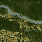

These lands border on the Sea of Soroshal, a place of sparce and small harbors, and savage storms. Of the lands shown above, to the south and east the land falls under jungles, while to the north the land rises rugged but steep in a range of mountains the dwaves call the Urzhnarks. The lands just north of Dohral are cut across by the Zeethan River that drains into Taarhthazwak Lake, which itself empties into the Illfaw Fen.
All items (15)


